
You may find with Gaia GPS that your recorded tracks are not the same length as the track lengths displayed on other iPhones, Androids, GPS devices, maps, or trail markers. Even the most recent models of iPhones, which have better GPS chips, can easily vary by 5-30% from other readings.
Despite the fact that Gaia GPS is calibrated to poll the GPS for maximum resolution and accuracy, the following factors confound estimation. We continue to explore ways to improve the estimation of distance from GPS data, but there are limitations that will always exist.
1. Trail Markers and Maps are Measured in Multiple Ways - Trail markers and maps use multiple methods to determine the length of trails. The most accurate measurements are done with a measuring wheel, which is rolled along the trail and has a revolution counter. Even with a wheel, there is plenty of opportunity for errors. The wheeler must be careful that the wheel does not slip, and wheelers have to decide which parts of trails to measure when there are difficult scrambling sections or two ways around a tree in the middle of a trail.
Trails are also measured using map estimations, which can be very inaccurate, or using GPS devices, which vary in resolution. 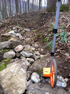
2. Your Device's GPS Accuracy - GPS accuracy varies across devices, and typically the newer the device the better the estimation. If you use a new phone, you will likely get a more accurate distance recording than a friend using a phone from a few years ago.
3. Satellite signal reception - Ideally, your device should have a clear, line-of-sight view of the sky in order to receive GPS data from satellites, however, the environments we explore are not necessarily conducive to this. Thick tree cover and cloud cover, the metal enclosure of a vehicle, or even tall buildings can interfere with your device's connection to GPS satellites.
Even in perfect conditions, phones GPS can show a range of acceptable errors. This can result in track lines that have some scattered points and appear similar to the one below:
4. Inaccuracies Accumulate Over Time - When a computer, like an iPhone, Garmin, or Android, records GPS locations, each location or track point, has a small amount of possible error. This error adds up over time, so your tracks are likely to be recorded as longer than you expect and longer tracks may have more noticeable errors.
Troubleshooting GPS performance
If you think you are experiencing less than optimal GPS performance, here are some things to try:
- First, check the trip screen to see your current GPS accuracy. It can be useful to set a benchmark to compare to as you make adjustments:
- Make sure your device has a clear, unobstructed view of the sky.
- Try turning your phone off and on a few times to clear any error on your GPS chip.
-
Check your location settings:
-
iOS users: Enabling 'Always' and 'Precise Location' will improve your track recording and GPS data accuracy. Here is how to check that.
- Here is some more info from Apple about Location Services and GPS accuracy: About privacy and Location Services in iOS and iPad
- Android users: Make sure that location settings for Gaia GPS are "Always allow" as described here: Android - Track recording inaccurate or has spikes
Also, double-check that you are not in "Battery Saver" mode and you are in Device only mode.
-
iOS users: Enabling 'Always' and 'Precise Location' will improve your track recording and GPS data accuracy. Here is how to check that.
-
Check your time, date and time zone settings to make sure they reflect your current position:
-
iOS: This is available under Settings > General > Date & Time. If possible, use Set Automatically.
- Android: This is available under Settings > General Management > Date and Time. If possible, use Automatic Date and Time and Automatic Time Zone.
-