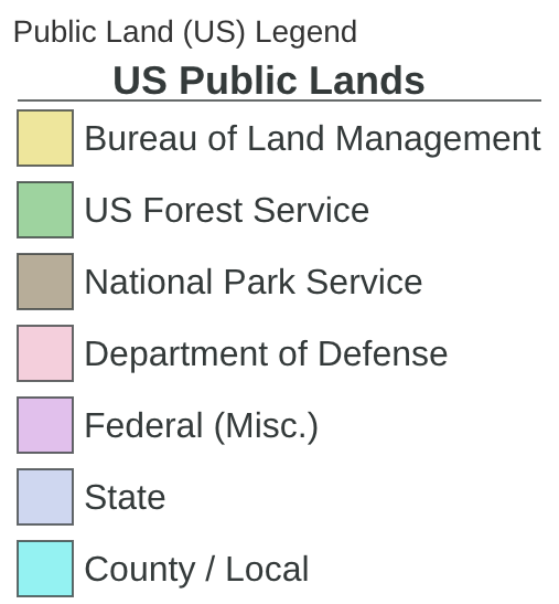
Premium members have access to the Public Lands (US) overlay. This legend is for the new version -- updated in Jan 2020.
This overlay displays land owned by the government. Depending on the department or state, the land is available for a range of uses. Make sure to check with the local department or state for regulations on land use.
Bureau of Land Management - Generally open for public use. Check local regulations here https://www.blm.gov/
Forest Service - Manage land for a variety of uses public access will vary. Find out more here: https://www.fs.fed.us/
National Park Service - National Parks' mission is to preserve natural and cultural resources for future generations and regulate the land with this in mind. Check out the park services website for help planning trips to these areas https://www.nps.gov/index.htm
Department of Defense / Military land - Not typically open to the public
State/County Land/Local - Recreation opportunities vary greatly in these areas. Make sure to look up the regulations for the area you are visiting to plan your trip.
Comments
6 comments
Seems like the public lands layer is raster based on the download size. Any chance you will produce a vector version? I want to download it for all of the West so I always know where there's some nearby BLM land for camping :)
@ParkeLoyd
Public Lands is Raster in Gaia GPS Classic, however, it's vector in the new version of Gaia GPS if you'd like to give that a try: https://itunes.apple.com/us/app/gaia-gps-topo-maps-and-hiking-trails/id1201979492?mt=8
Also, if you reduce the maximum zoom level while downloading, you'll reduce the size of the download dramatically.
This might be obvious for others, but are we to assume the areas having no color shading are areas that are for "public" use? One aspect of the legends that would help tremendously—in my opinion—are definitions of the legend terms. i.e. what does it mean for an area to be shaded as a "State" feature? Or otherwise. Thanks!
Hey Derek,
The Public Land overlay shades areas owned by the US government, some are open to public use and some not. Generally, BLM land is open to the public and some forest service land, but restrictions vary and you should double-check with your local forest service websites for more info.
Thanks for your feedback on this legend. I updated this article with more information on the different landowners and where to find more information about regulations for each.
Hope that helps :)
I just upgraded to Premium, and see more of the features on phone and computer. Great. but I don't see how to turn on Public Land Overlay. My list of overlays includes waypoints, wp labels, tracks, hikes, grid. I also don't see it in the LONG list of Premium map layers. What I"m after is BLM boundaries in WY. What do you reckon? thanks...
@MechEngr1
The Public Land Overlay is filed under 'Feature/Weather Overlays' in the map catalog.
Send an email to support@gaiagps.com if you have any questions about that - we're happy to help.
Article is closed for comments.